Trail Development Application: September, 2023
You may not yet be aware of a new trail development proposal from the Contagious Mountain Bike Club (CMBC). This trail development proposal may come before City Council for approval, so it might be beneficial to have some background information prior to that time.
An outline of the proposal was sent to Active Trails Whitehorse Association (ATWA) by Colby Knowler Projects & Trails Coordinator Parks on August 29, 2023. That information was sent to all ATWA associates. It was made clear that they should make personal submissions on the subject if they had some comments they would like to make.
The attachment below is Keith Lay's personal submission concerning this application, which was submitted on September 14.
To: Colby Knowler
From: Keith Lay
Re: Contagious Mountain Bike Club Trail Development Application
Date: 9/14/2023
According to the information received the trail application proposal involves the construction of a “single track link from RIP (Rest in Peace) back to Magnusson parking lot that would provide a climbing route off away from motorized traffic on Grey Mountain road, creating a viable continuous climb trail to Magnusson parking lot as it continues from RIPURT.”
Comment: The suggestion is that this trail would provide a “climbing route” for mountain bikers that would allow them to avoid using the Grey Mountain Road to get them from RIP to the Magnusson parking lot, and that this would improve safety for all riders.
This may give people the impression that it is a difficult “climb” from RIP to the Magnusson parking lot. It is not. In fact, one hardly notices that the road goes uphill at all between the two points. The gain in elevation is around fourteen metres.
As to whether or not it would improve safety, the suggestion is debatable. One might well argue that it is safer to use a road that is maintained by the City of Whitehorse than it is to use a trail maintained by a user group.
Having used the road for running over the course of many years I have never experienced any concern with vehicle traffic. And, as a runner, I have far more chance of injury running on Chadburn Lake trails than on the Grey Mountain Road.
The information package provided says that the new trail “will also create a valuable grooming loop in winter as there is currently no connection back to Magnusson area for the Snow Dog trail groomer.”
Comment: Unfortunately, there is no information given as to what specific trails are packed for fat biking in the winter. This would allow one to determine if there is an alternate way to get back to the Magnusson area that would allow the packing of other fat biking trails along the way.
Would it not make for a better fat biking trail if it was packed twice? Apparently, fat bikers prefer trails that are more compacted than Nordic trails, as this allows them to ride in a greater range of conditions.
If so, then a return packing trip to the Magnusson area via RIP and other fat biking trails would improve such trails for the use intended.
It would be good to know how the club handles this perceived problem now. Does it shuttle the grooming equipment between the two areas?
The application should indicate exactly what type of equipment is being used by the club to groom fat biking trails. If the grooming equipment can be used on the Grey Mountain Road, which seems likely as it would have to cross the road to access the proposed trail, then why can it not be driven up the road to the Magnusson parking lot? (It takes nine minutes to walk the distance involved.)
And, as will be mentioned later, there is an existing trail connection back to the Magnusson parking area from RIP that parallels the Grey Mountain Road. As such, there needs to be an explanation given as to why this route is not being considered.
In any case, it seems overkill to impact 800 metres of forest to create a 1.5-metre-wide trail for the sake of eliminating a little inconvenience.
“The trail will be built with mountain biking in mind and encourage people to ride up grey mountain rather than drive.”
Comment: The second part of the above statement needs explanation. Why would the building of the proposed trail “encourage people to ride up Grey Mountain rather than drive?”
The Magnusson parking area is a very convenient area from which to begin one’s preferred recreational pursuit, as you can access so many trails from that location. So, people will continue to drive to that very popular site.
As for the first part of the above statement it is nice to see an admission that this proposed trail is primarily a mountain bike trail and if built will be packed and used in winter for fat biking. For all intents and purposes, the proposed trail will be a single-use mountain bike trail. Of course, the claim is made that the trail is open for skiing and snowshoeing in winter.
However, “cross country ski “trails typically have a classic track that is set into the snow by a grooming implement . . . Classic skiers rely on the groomed classic track to guide their skis . . .” (See https://www.sciencedirect.com/science/article/abs/pii/S2213078019300246)
Is it the intent of the CMBC to also put down a classic track for cross-country skiers? I doubt it. The trail will be groomed for fat bikes in winter, not for classic cross-country skiers. Groomed fat bike trails are not groomed classic ski trails and they do not make for enjoyable classic skiing.
It is somewhat strange that the trail will be open to snowshoe use in winter as “snowshoes can cause indents on these groomed areas [areas groomed for XC skiing and fat biking], thus resulting in safety issues and [potentially] making the route unusable for skiers and fat bikers.” (See https://www.snowshoemag.com/trail-etiquette-for-snowshoeing-and-winter-hiking/.)
Of course, snowshoe users are often asked to use unpacked trails prior to them being groomed for fat biking. Perhaps this is why the trail will be open to snowshoe users, although they will have to find a way to avoid the packed section of the proposed trail after it is machined groomed.
According to the Chadburn Lake Park Management Plan, “the cumulative impact of new trails and/or other infrastructure should not substantially alter the wilderness experience.” (p. 19 of Management Plan)
Comment: People will have different views as to what constitutes a substantial alteration of the wilderness experience.
However, this proposed trail is 800 metres long. To get an idea as to how long this is, walk twice around the 400-metre running track in Whitehorse. Some 1200 square metres of land will be impacted one way or another if this trail is built. Of course, we never consider the plant, animal, and bird life that will be affected by the construction and long-term use of the trail.
It should also be realized that the proposed trail is a recreational trail. The City of Whitehorse tells us that there are “an estimated 230 km of trails of city-wide significance and over 850 km of local and neighbourhood trails used by Whitehorse residents.”
We should be very careful about adding more to the list. Instead, we should be consolidating what we have rather than adding more to the mix. If we keep building new trails, we will continue to degrade the wilderness aspect of our city.
Main Concern:
The main concern with this application lies in the fact that the building of a new trail is simply not necessary as there already is a trail connection from where RIP contacts the Grey Mountain Road to the Magnusson parking area.
Photos that may help to illustrate this can be found at the following site: [A photo album supporting my comments was sent.]
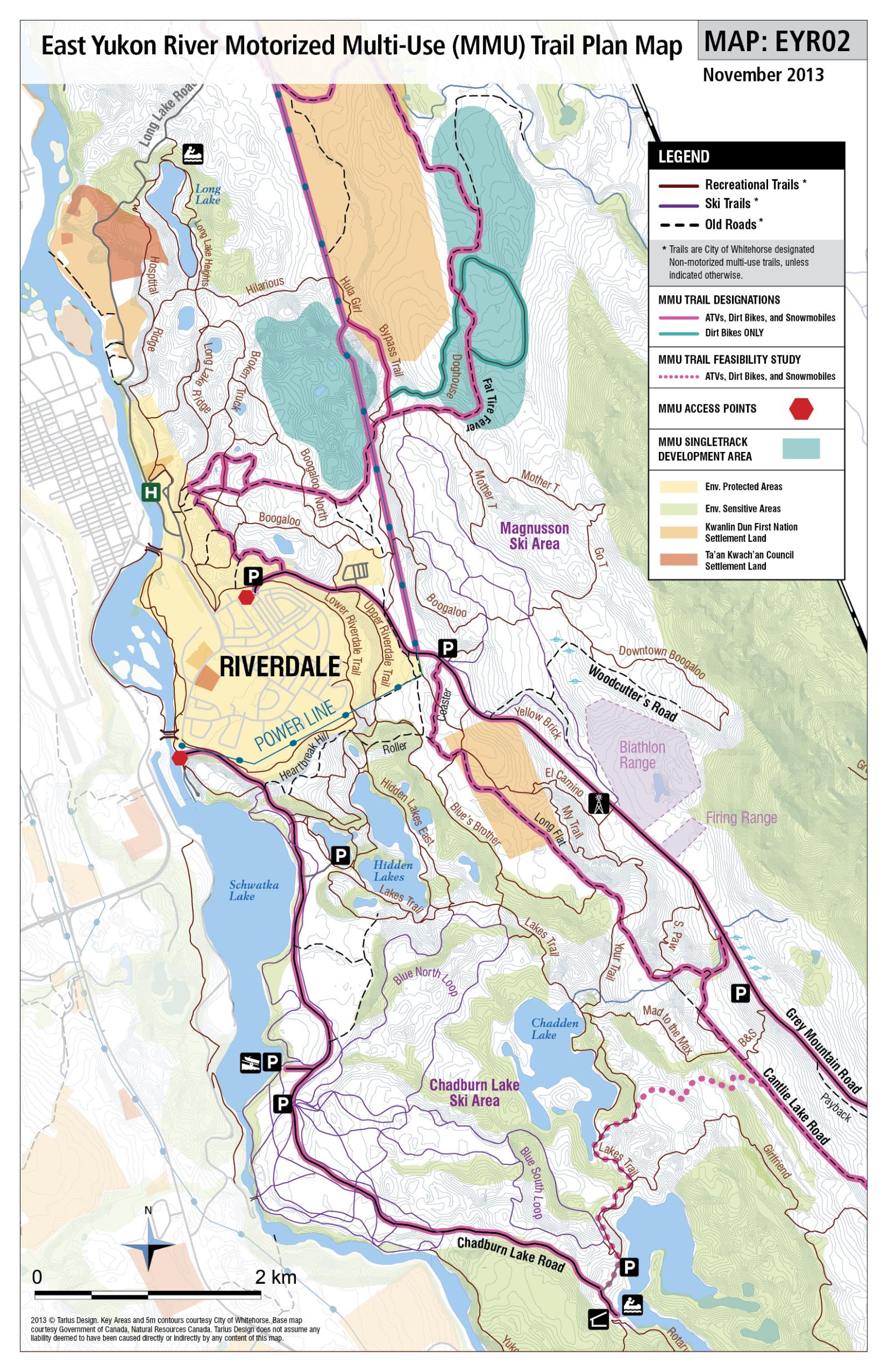
Even on the image provided in the information package concerning the trail proposal, you can just make out the existing trail on the west side of the Grey Mountain Road. This “Old Road” can be seen on Gaia Maps. Although the “Old Road” appears to turn south before it comes to the Power Line, there is a branch that carries on beside the road to the Power Line.
This trail is .52 kms long or 520 metres in length, takes about six minutes to walk, and ascends about ten metres.
According to the East Yukon River Trail Plan, the latter trail is an “Old Road” and considered a Non-Motorized Multi-Use Trail. (See https://www.whitehorse.ca/wp-content/uploads/2022/06/636356372502630000.jpeg.)
It seems that the “Old Road” is also indicated on the Whitehorse East Trails App as a Green Line. And, the Green Line indicates a branch that cuts towards the Power Line and parallels the Grey Mountain Road.
It seems obvious by the image provided in the trail development package that the club does not intend to use this aforementioned existing trail that parallels the Grey Mountain Road from RIP to the Power Line.
Unfortunately, it is hard to tell by the image provided as to whether or not the club plans to use the existing trail that goes from the Power Line to the Magnusson parking area.
This trail is .25 kms long or 250 metres in length, takes about three minutes to walk, and ascends about four metres. This is the only part of the route that needs some work, as the trail (although obvious) needs some clearing.
If the club does not feel this section of the existing trail is suitable, then it could simply cross to the other side of the road at the Power Line where an existing trail combined with open spaces leads right to the Magnusson parking area. [Reference was made to the sent photo album that contains a picture of the area in question.]
The application does not mention the existence of the “Old Road” trail and the branch that leads right to the Magnusson parking area. Nor does it mention the possibility of crossing the Grey Mountain Road at the Power Line in order to reach the Magnusson parking area, which would avoid doing any work on the last 250 metres of the trail located on the south side of the road.
The application raises more questions than answers. If there are alternatives that would avoid the construction of a new trail through Chadburn Lake Park, then those alternatives should be considered and explanations provided if the alternatives prove unacceptable. Until that time the application should not proceed.
As an associate of ATWA I appreciate the opportunity to present my personal comments on this proposed trail development project.
Keith Lay (An associate of Active Trails Whitehorse Association)
Trail Development Policy (Approved June 25, 2018): See
https://www.whitehorse.ca/home/showpublisheddocument/10076/636657131456170000.
March 31, 2018 update - DRAFT Trail Development Policy:
The City finally provided the public with a two week window to comment on a DRAFT Trail Development Policy. The City’s survey deadline was March 30, 2018.
City’s webpage on the DRAFT Trail Development Policy: http://whitehorse.ca/departments/parks-and-community-development/trails/planning-and-consultation/draft-trail-development-policy
To view DRAFT Trail Development Policy: http://whitehorse.ca/home/showdocument?id=9706
To view ATWA’s submission on the DRAFT Trail Development Policy, click on the icon below.
You may not yet be aware of a new trail development proposal from the Contagious Mountain Bike Club (CMBC). This trail development proposal may come before City Council for approval, so it might be beneficial to have some background information prior to that time.
An outline of the proposal was sent to Active Trails Whitehorse Association (ATWA) by Colby Knowler Projects & Trails Coordinator Parks on August 29, 2023. That information was sent to all ATWA associates. It was made clear that they should make personal submissions on the subject if they had some comments they would like to make.
The attachment below is Keith Lay's personal submission concerning this application, which was submitted on September 14.
To: Colby Knowler
From: Keith Lay
Re: Contagious Mountain Bike Club Trail Development Application
Date: 9/14/2023
According to the information received the trail application proposal involves the construction of a “single track link from RIP (Rest in Peace) back to Magnusson parking lot that would provide a climbing route off away from motorized traffic on Grey Mountain road, creating a viable continuous climb trail to Magnusson parking lot as it continues from RIPURT.”
Comment: The suggestion is that this trail would provide a “climbing route” for mountain bikers that would allow them to avoid using the Grey Mountain Road to get them from RIP to the Magnusson parking lot, and that this would improve safety for all riders.
This may give people the impression that it is a difficult “climb” from RIP to the Magnusson parking lot. It is not. In fact, one hardly notices that the road goes uphill at all between the two points. The gain in elevation is around fourteen metres.
As to whether or not it would improve safety, the suggestion is debatable. One might well argue that it is safer to use a road that is maintained by the City of Whitehorse than it is to use a trail maintained by a user group.
Having used the road for running over the course of many years I have never experienced any concern with vehicle traffic. And, as a runner, I have far more chance of injury running on Chadburn Lake trails than on the Grey Mountain Road.
The information package provided says that the new trail “will also create a valuable grooming loop in winter as there is currently no connection back to Magnusson area for the Snow Dog trail groomer.”
Comment: Unfortunately, there is no information given as to what specific trails are packed for fat biking in the winter. This would allow one to determine if there is an alternate way to get back to the Magnusson area that would allow the packing of other fat biking trails along the way.
Would it not make for a better fat biking trail if it was packed twice? Apparently, fat bikers prefer trails that are more compacted than Nordic trails, as this allows them to ride in a greater range of conditions.
If so, then a return packing trip to the Magnusson area via RIP and other fat biking trails would improve such trails for the use intended.
It would be good to know how the club handles this perceived problem now. Does it shuttle the grooming equipment between the two areas?
The application should indicate exactly what type of equipment is being used by the club to groom fat biking trails. If the grooming equipment can be used on the Grey Mountain Road, which seems likely as it would have to cross the road to access the proposed trail, then why can it not be driven up the road to the Magnusson parking lot? (It takes nine minutes to walk the distance involved.)
And, as will be mentioned later, there is an existing trail connection back to the Magnusson parking area from RIP that parallels the Grey Mountain Road. As such, there needs to be an explanation given as to why this route is not being considered.
In any case, it seems overkill to impact 800 metres of forest to create a 1.5-metre-wide trail for the sake of eliminating a little inconvenience.
“The trail will be built with mountain biking in mind and encourage people to ride up grey mountain rather than drive.”
Comment: The second part of the above statement needs explanation. Why would the building of the proposed trail “encourage people to ride up Grey Mountain rather than drive?”
The Magnusson parking area is a very convenient area from which to begin one’s preferred recreational pursuit, as you can access so many trails from that location. So, people will continue to drive to that very popular site.
As for the first part of the above statement it is nice to see an admission that this proposed trail is primarily a mountain bike trail and if built will be packed and used in winter for fat biking. For all intents and purposes, the proposed trail will be a single-use mountain bike trail. Of course, the claim is made that the trail is open for skiing and snowshoeing in winter.
However, “cross country ski “trails typically have a classic track that is set into the snow by a grooming implement . . . Classic skiers rely on the groomed classic track to guide their skis . . .” (See https://www.sciencedirect.com/science/article/abs/pii/S2213078019300246)
Is it the intent of the CMBC to also put down a classic track for cross-country skiers? I doubt it. The trail will be groomed for fat bikes in winter, not for classic cross-country skiers. Groomed fat bike trails are not groomed classic ski trails and they do not make for enjoyable classic skiing.
It is somewhat strange that the trail will be open to snowshoe use in winter as “snowshoes can cause indents on these groomed areas [areas groomed for XC skiing and fat biking], thus resulting in safety issues and [potentially] making the route unusable for skiers and fat bikers.” (See https://www.snowshoemag.com/trail-etiquette-for-snowshoeing-and-winter-hiking/.)
Of course, snowshoe users are often asked to use unpacked trails prior to them being groomed for fat biking. Perhaps this is why the trail will be open to snowshoe users, although they will have to find a way to avoid the packed section of the proposed trail after it is machined groomed.
According to the Chadburn Lake Park Management Plan, “the cumulative impact of new trails and/or other infrastructure should not substantially alter the wilderness experience.” (p. 19 of Management Plan)
Comment: People will have different views as to what constitutes a substantial alteration of the wilderness experience.
However, this proposed trail is 800 metres long. To get an idea as to how long this is, walk twice around the 400-metre running track in Whitehorse. Some 1200 square metres of land will be impacted one way or another if this trail is built. Of course, we never consider the plant, animal, and bird life that will be affected by the construction and long-term use of the trail.
It should also be realized that the proposed trail is a recreational trail. The City of Whitehorse tells us that there are “an estimated 230 km of trails of city-wide significance and over 850 km of local and neighbourhood trails used by Whitehorse residents.”
We should be very careful about adding more to the list. Instead, we should be consolidating what we have rather than adding more to the mix. If we keep building new trails, we will continue to degrade the wilderness aspect of our city.
Main Concern:
The main concern with this application lies in the fact that the building of a new trail is simply not necessary as there already is a trail connection from where RIP contacts the Grey Mountain Road to the Magnusson parking area.
Photos that may help to illustrate this can be found at the following site: [A photo album supporting my comments was sent.]
Even on the image provided in the information package concerning the trail proposal, you can just make out the existing trail on the west side of the Grey Mountain Road. This “Old Road” can be seen on Gaia Maps. Although the “Old Road” appears to turn south before it comes to the Power Line, there is a branch that carries on beside the road to the Power Line.
This trail is .52 kms long or 520 metres in length, takes about six minutes to walk, and ascends about ten metres.
According to the East Yukon River Trail Plan, the latter trail is an “Old Road” and considered a Non-Motorized Multi-Use Trail. (See https://www.whitehorse.ca/wp-content/uploads/2022/06/636356372502630000.jpeg.)
It seems that the “Old Road” is also indicated on the Whitehorse East Trails App as a Green Line. And, the Green Line indicates a branch that cuts towards the Power Line and parallels the Grey Mountain Road.
It seems obvious by the image provided in the trail development package that the club does not intend to use this aforementioned existing trail that parallels the Grey Mountain Road from RIP to the Power Line.
Unfortunately, it is hard to tell by the image provided as to whether or not the club plans to use the existing trail that goes from the Power Line to the Magnusson parking area.
This trail is .25 kms long or 250 metres in length, takes about three minutes to walk, and ascends about four metres. This is the only part of the route that needs some work, as the trail (although obvious) needs some clearing.
If the club does not feel this section of the existing trail is suitable, then it could simply cross to the other side of the road at the Power Line where an existing trail combined with open spaces leads right to the Magnusson parking area. [Reference was made to the sent photo album that contains a picture of the area in question.]
The application does not mention the existence of the “Old Road” trail and the branch that leads right to the Magnusson parking area. Nor does it mention the possibility of crossing the Grey Mountain Road at the Power Line in order to reach the Magnusson parking area, which would avoid doing any work on the last 250 metres of the trail located on the south side of the road.
The application raises more questions than answers. If there are alternatives that would avoid the construction of a new trail through Chadburn Lake Park, then those alternatives should be considered and explanations provided if the alternatives prove unacceptable. Until that time the application should not proceed.
As an associate of ATWA I appreciate the opportunity to present my personal comments on this proposed trail development project.
Keith Lay (An associate of Active Trails Whitehorse Association)
Trail Development Policy (Approved June 25, 2018): See
https://www.whitehorse.ca/home/showpublisheddocument/10076/636657131456170000.
March 31, 2018 update - DRAFT Trail Development Policy:
The City finally provided the public with a two week window to comment on a DRAFT Trail Development Policy. The City’s survey deadline was March 30, 2018.
City’s webpage on the DRAFT Trail Development Policy: http://whitehorse.ca/departments/parks-and-community-development/trails/planning-and-consultation/draft-trail-development-policy
To view DRAFT Trail Development Policy: http://whitehorse.ca/home/showdocument?id=9706
To view ATWA’s submission on the DRAFT Trail Development Policy, click on the icon below.
| 180329_final_atwa_submission_on_draft_trail_development_policy.pdf |
______________________________________________________________________
Letter to Mayor & Council from Active Trails Whitehorse Association
Re: Trail Development Policy and Trail Application Process
Dated: Nov 29, 2017
This letter will be read before Mayor & Council at the Dec. 04, 2017 Council meeting by an ATWA Delegate.
There are two issues mentioned in the Council Questions & Answers of September 11 2017, which we will address. (See above document at this link: http://www.whitehorse.ca/Home/ShowDocument?id=9100)
Trail Development Policy:
The first issue deals with Council’s direction to administration to produce a Trail Development Policy, which was to have been completed by the spring of 2017, but will not now be presented to a Council and Senior Management meeting until March of 2018.
Although administration says in the Council Questions & Answers to which we have referred, that it “continues to work with stakeholders, trail stewards, and land owners to develop” this policy, there was no indication as to how the public is to be involved.
As you are all aware the 2007 Trail Plan’s Guiding Principle of Inclusiveness “recognizes the importance of the trail system to residents and visitors alike, and is committed to including the public in determining guidelines for trail system development, use, preservation and maintenance.” We believe that the time for administration to solicit public input would be prior to the policy being presented before CASM.
If the public is to be involved, then it needs to know what issues/topics are to be addressed by the policy. We understand that one topic that is to be considered concerns how the City is to deal with unauthorized trails. Another that has been mentioned is the necessity for an open and transparent trail development application process.
However, there are a number of other subjects that may be appropriate to include: impact of trail construction on Environmentally Sensitive Areas; decommissioning of trails; impact of trail construction on plant, animal, and bird life; impact of trail construction on other trails in the area, and on the users of those trails; impact of trail building on local communities; philosophy behind trail development within the City of Whitehorse; the reasons why and for whom are we building new trails; and how to determine whether or not a proposed new trail is appropriate for construction.
In the interests of public awareness and transparency on the important topic of trail development and management, we urge the City to inform the public as to what specific issues are to be addressed in the policy, how the public can be involved in its development, and the current state of consultation efforts with stakeholders, trail stewards, and land owners.
Trail Development Applications:
The second issue is the lack of current information surrounding trail development applications, and the apparent failure of administration to recognize the importance and necessity of public involvement concerning such applications.
According to administration “trail stewards and land owners” [will be consulted] “prior to the approval of any individual trail applications.” (See Council Questions & Answers of 09/11/17 http://www.whitehorse.ca/Home/ShowDocument?id=9100)
However, in its response administration fails to give any assurance that the public will have an opportunity to both review and comment on new trail development applications.
This despite the fact that the 2007 Trail Plan calls for public involvement in “trail system development.”
As the trail stewards with whom administration consults, are often the same bodies which either make development applications, or support other applicant’s proposals, it is essential that the public is also consulted. Otherwise the whole process will lack meaningful oversight, input, and transparency.
Administration suggests, “Most of the proposed trails anticipated for 2018 will be included in the neighbourhood trail task force reports.” See Council Questions & Answers of 09/11/17 http://www.whitehorse.ca/Home/ShowDocument?id=9100)
However, this implies that there will be other trail development proposals that will be considered outside of those reports.
We ask the following:
That the public be informed about, and be given opportunities for input on any trail development application received by administration since the demise of the Whitehorse Trail & Greenways Committee this past September, and all future applications submitted.
That City Council makes clear to the public how a trail application is made given the current situation, i.e. the absence of a trail development policy and the dissolution of the WTGC, what body must approve or deny the application, and the process involved in seeking approval.
Thank you for your attention to these matters.
Active Trails Whitehorse Association
_________________________________________________________________________________________
March 10, 2017:
The following is an ATWA letter published in both the Whitehorse Star and Yukon News.
Note: The Whitehorse Trail & Greenways Committee (WTGC) was disbanded in September of 2017.
How well are Whitehorse residents included in trail building decisions?
Inclusiveness is one of the four guiding principles of the 2007 Trail Plan. This principle commits the City “to including the public in determining guidelines for trail system development, use, preservation and maintenance.”
Active Trails Whitehorse Association (ATWA) believes that the current trail development application procedure fails to ensure public involvement. Here is why.
The current procedure requires any individual or organization wishing to construct a trail within the City of Whitehorse, to submit a Trail Development Application form to the chairperson of the Whitehorse Trail and Greenways Committee (WTGC), three weeks prior to its regularly scheduled meeting. The completed form is distributed to members of the WTGC for their review, and the proposal will usually be discussed at its next meeting.
The committee could recommend that City administration approve or deny the application, or approve the application with conditions. Any denied application could be revisited in the future.
In August of 2016, in an ATWA meeting with Parks and Community Development representatives, the latter “agreed that it was a good recommendation to attach trail applications to WTGC meeting agendas for public viewing in the future.”
This would have at least given the public an opportunity to view the application, although it would have provided little time for citizens to provide comments, as agendas are released only a few days before committee meetings. However, this recommendation was not adopted when the next trail development application was placed on a subsequent WTGC agenda.
At present, neither the public nor the majority of the members of associations represented on the WTGC, are given the opportunity to review and/or comment on these applications prior to them coming before the WTGC.
ATWA suggests that when a trail development application is received by the chairperson, that it be immediately put on the City’s website under an appropriate title (Trail Development Applications), so that the public and members of the associations represented on the WTGC, are able to review the proposal and submit comments to the chairperson within the three week period prior to the application’s presentation before the WTGC.
Committee members could make more knowledgeable decisions with regard to trail development applications, if they had additional input from both the public and the members of committee representative’s respective associations.
Trail building decisions should not be made in a rush. In other words, it may be appropriate to delay a decision until the next WTGC meeting, in order to allow representatives to better digest the input they have received, and perhaps obtain additional information with respect to some of the collected comments.
Citizens should be given a meaningful opportunity to participate in the trail application process. Yes, this will require more time and effort on the part of City staff and the WTGC, but public participation is what the 2007 Trail Plan calls for, and for good reason: all citizens and the trail network they love will benefit from an open, inclusive process.
Keith Lay, President
ATWA
www.activetwa.org
Active Trails Whitehorse Association
Preliminary suggestions: Steps to Trail Development Approval:
December 6, 2016
Note: The Whitehorse Trail & Greenways Committee (WTGC) was disbanded in September of 2017.
Note: Some consideration should be given to hearing these applications at a special meeting of the WTGC, as it would seem that much time is now spent on dealing with said applications at the expense of other important work of the Committee.
In addition, ATWA is not sure that a three-week review process provides the public with adequate time to consider and weigh in on each application. ATWA prefers the approach of establishing set deadlines for each season (2), with full information on a public website concerning each Trail Development Application plus announcements in local newspapers. Trails are not urgent matters; trail development applications can wait in order to ensure that each one is subject to a thorough review, and ample time is given to allow for public input.
Note: At present there does not appear to be an “appropriate form” to deal with those who would like to address the Committee on issues other than the construction of a trail. An appropriate process to follow for such situations, and one that is known to the public should be developed.
Trail Development Application Form: Possible additions/changes to the current application form
What is the location of the trail? A general location should be given along with A GPS start point and a GPS finish point.
How long is the trail to be?
Is the trail to be single-track or double track?
Is the trail intended to be motorized or non-motorized, or built to accommodate both?
Is the trail intended to be a single use trail? (In other words, will only one type of use be permitted in winter, in summer, or over the entire year?)
If applicable, what other type of recreationalist will be able to use the trail?
Is the trail intended to accommodate technical structures?
If the trail is located within a City of Whitehorse regional park, how does the trail fit with the goals and Mission Statement of the park’s Management Plan?
Applicants should be required to consult with more than just the association that may represent his/her user group.
If there is to be a cost to the City of this trail development, then an estimate of that cost should be given.
How does this trail compliment the trail system in the immediate area?
Are there any environmentally sensitive areas through which this trail is to cross?
Are there any non-designated trails in the immediate area that would be replaced by the trail you wish to construct?
Does this trail fall within the maximum trail density threshold of the area? (Applicable only if the City has determined trail density thresholds for the area in question.)
Who is/are the owner(s) of the land through which the trail will be built? Have these owners been consulted? (This may be something that City administration might have to do rather than the trail development applicant.)
Active Trails Whitehorse Association
The following is an ATWA letter published in both the Whitehorse Star and Yukon News.
Note: The Whitehorse Trail & Greenways Committee (WTGC) was disbanded in September of 2017.
How well are Whitehorse residents included in trail building decisions?
Inclusiveness is one of the four guiding principles of the 2007 Trail Plan. This principle commits the City “to including the public in determining guidelines for trail system development, use, preservation and maintenance.”
Active Trails Whitehorse Association (ATWA) believes that the current trail development application procedure fails to ensure public involvement. Here is why.
The current procedure requires any individual or organization wishing to construct a trail within the City of Whitehorse, to submit a Trail Development Application form to the chairperson of the Whitehorse Trail and Greenways Committee (WTGC), three weeks prior to its regularly scheduled meeting. The completed form is distributed to members of the WTGC for their review, and the proposal will usually be discussed at its next meeting.
The committee could recommend that City administration approve or deny the application, or approve the application with conditions. Any denied application could be revisited in the future.
In August of 2016, in an ATWA meeting with Parks and Community Development representatives, the latter “agreed that it was a good recommendation to attach trail applications to WTGC meeting agendas for public viewing in the future.”
This would have at least given the public an opportunity to view the application, although it would have provided little time for citizens to provide comments, as agendas are released only a few days before committee meetings. However, this recommendation was not adopted when the next trail development application was placed on a subsequent WTGC agenda.
At present, neither the public nor the majority of the members of associations represented on the WTGC, are given the opportunity to review and/or comment on these applications prior to them coming before the WTGC.
ATWA suggests that when a trail development application is received by the chairperson, that it be immediately put on the City’s website under an appropriate title (Trail Development Applications), so that the public and members of the associations represented on the WTGC, are able to review the proposal and submit comments to the chairperson within the three week period prior to the application’s presentation before the WTGC.
Committee members could make more knowledgeable decisions with regard to trail development applications, if they had additional input from both the public and the members of committee representative’s respective associations.
Trail building decisions should not be made in a rush. In other words, it may be appropriate to delay a decision until the next WTGC meeting, in order to allow representatives to better digest the input they have received, and perhaps obtain additional information with respect to some of the collected comments.
Citizens should be given a meaningful opportunity to participate in the trail application process. Yes, this will require more time and effort on the part of City staff and the WTGC, but public participation is what the 2007 Trail Plan calls for, and for good reason: all citizens and the trail network they love will benefit from an open, inclusive process.
Keith Lay, President
ATWA
www.activetwa.org
Active Trails Whitehorse Association
Preliminary suggestions: Steps to Trail Development Approval:
December 6, 2016
Note: The Whitehorse Trail & Greenways Committee (WTGC) was disbanded in September of 2017.
- Trail Development Applications should be sent to the Chair at least three weeks in advance of a WTGC regular meeting. (This according to the Terms of Reference of the WTGC.)
- Upon receipt the TDA form is checked by the Chair to ensure it has been filled out properly.
- If filled out properly the application is sent to each member of the WTGC for review and is also posted on the City’s website under WTGC, with instructions as to how members of the public can make comments with regard to the application. (Perhaps a separate heading on the site could be created, such as one with the title Trail Development Applications.)
- Immediately upon receipt each member of the Committee will ensure a copy of the application is sent to all members of his/her respective associations. Members will be asked to review the document and if they have any questions, concerns, or additional information re: the application, they are to send them directly to the Chair with a copy to the association’s representative on the WTGC.
- The application is reviewed at the next appropriate meeting of the WTGC (as long as everyone has at least three weeks to review the application.) Input from the general public, committee members, and members of the associations represented on the committee will be considered.
- The applicant is required to attend the WTGC meeting at which the Trail Development Application will be considered.
- The application will be recommended for approval, denied, or denied until the applicant has satisfied the committee that certain conditions have been or will be met. (If the latter, the application would then be re-considered at a later date.)
- Members of the public and members of associations represented on the WTGC, should be informed that they are welcome to attend as observers when the Trail Development Application is heard before the Committee.
- Members of the public should be informed that if they disagree with the decision of the Committee to approve or deny an application, then an appeal could be made directly to City Council.
Note: Some consideration should be given to hearing these applications at a special meeting of the WTGC, as it would seem that much time is now spent on dealing with said applications at the expense of other important work of the Committee.
In addition, ATWA is not sure that a three-week review process provides the public with adequate time to consider and weigh in on each application. ATWA prefers the approach of establishing set deadlines for each season (2), with full information on a public website concerning each Trail Development Application plus announcements in local newspapers. Trails are not urgent matters; trail development applications can wait in order to ensure that each one is subject to a thorough review, and ample time is given to allow for public input.
Note: At present there does not appear to be an “appropriate form” to deal with those who would like to address the Committee on issues other than the construction of a trail. An appropriate process to follow for such situations, and one that is known to the public should be developed.
Trail Development Application Form: Possible additions/changes to the current application form
- If the applicant is not a particular association, but rather an individual, that individual should be required to list all trail user groups of which he/she is a member.
- Number 4 in the Application should now be rewritten as the applicant may be asking to develop a new trail, an existing trail, an unauthorized trail, or a combination of any of the aforementioned.
- The applicant should be asked to give some of the following information: (If applicable.)
What is the location of the trail? A general location should be given along with A GPS start point and a GPS finish point.
How long is the trail to be?
Is the trail to be single-track or double track?
Is the trail intended to be motorized or non-motorized, or built to accommodate both?
Is the trail intended to be a single use trail? (In other words, will only one type of use be permitted in winter, in summer, or over the entire year?)
If applicable, what other type of recreationalist will be able to use the trail?
Is the trail intended to accommodate technical structures?
If the trail is located within a City of Whitehorse regional park, how does the trail fit with the goals and Mission Statement of the park’s Management Plan?
Applicants should be required to consult with more than just the association that may represent his/her user group.
If there is to be a cost to the City of this trail development, then an estimate of that cost should be given.
How does this trail compliment the trail system in the immediate area?
Are there any environmentally sensitive areas through which this trail is to cross?
Are there any non-designated trails in the immediate area that would be replaced by the trail you wish to construct?
Does this trail fall within the maximum trail density threshold of the area? (Applicable only if the City has determined trail density thresholds for the area in question.)
Who is/are the owner(s) of the land through which the trail will be built? Have these owners been consulted? (This may be something that City administration might have to do rather than the trail development applicant.)
Active Trails Whitehorse Association