Important reminder to snowmobilers:
At a January 2014 public meeting on the new EYR Trail Plan, City staff mentioned to residents that snowmobiles are prohibited from driving to the Hidden Lakes, as these lakes are surrounded by Environmentally Sensitive Areas (ESA) which are prohibited to snowmobiles at all times.
There are other nearby lakes that can legitimately be reached by snowmobiles. Examples:
Please respect our environment, and keep your snowmobiles on designated motorized trails.
_________________________________________________________________________________________
At a January 2014 public meeting on the new EYR Trail Plan, City staff mentioned to residents that snowmobiles are prohibited from driving to the Hidden Lakes, as these lakes are surrounded by Environmentally Sensitive Areas (ESA) which are prohibited to snowmobiles at all times.
There are other nearby lakes that can legitimately be reached by snowmobiles. Examples:
- Snowmobiles may drive up the Grey Mountain Road to reach the Cantlie Lake trail.
- Snowmobiles may drive along the Chadburn Lake Road to reach Chadburn Lake, but are prohibited from all slopes surrounding Chadburn Lake which also are ESAs.
Please respect our environment, and keep your snowmobiles on designated motorized trails.
_________________________________________________________________________________________
Aug. 18 2015 The City of Whitehorse received reports that trail building activity is occurring off the Go-T trail in the Magnusson area of Grey Mountain. This trail was not approved by the City.
http://whitehorse.ca/Home/Components/News/News/1144/31?backlist=%2fhome
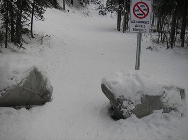
July 2015 The City added barriers on the side of the trail leading up to Pee Wee Hill to prevent motorized trespassing on this trail. Pee Wee Hill was formally designated non-motorized by City Council in Jan 2014.
http://whitehorse.ca/Home/Components/News/News/1144/31?backlist=%2fhome
July 2015 The City added barriers on the side of the trail leading up to Pee Wee Hill to prevent motorized trespassing on this trail. Pee Wee Hill was formally designated non-motorized by City Council in Jan 2014.
Spring 2015 update:
The City is still working on the preparation of a more detailed city-wide map of motorized trails that include the EYR Trail Plan.
Its most recent effort can be found at http://www.whitehorse.ca/home/showdocument?id=4210
Or, just go to the latest ATV Trail Map on the City's website.
January 2014 update - New trail designation for Riverdale: what does it look like?
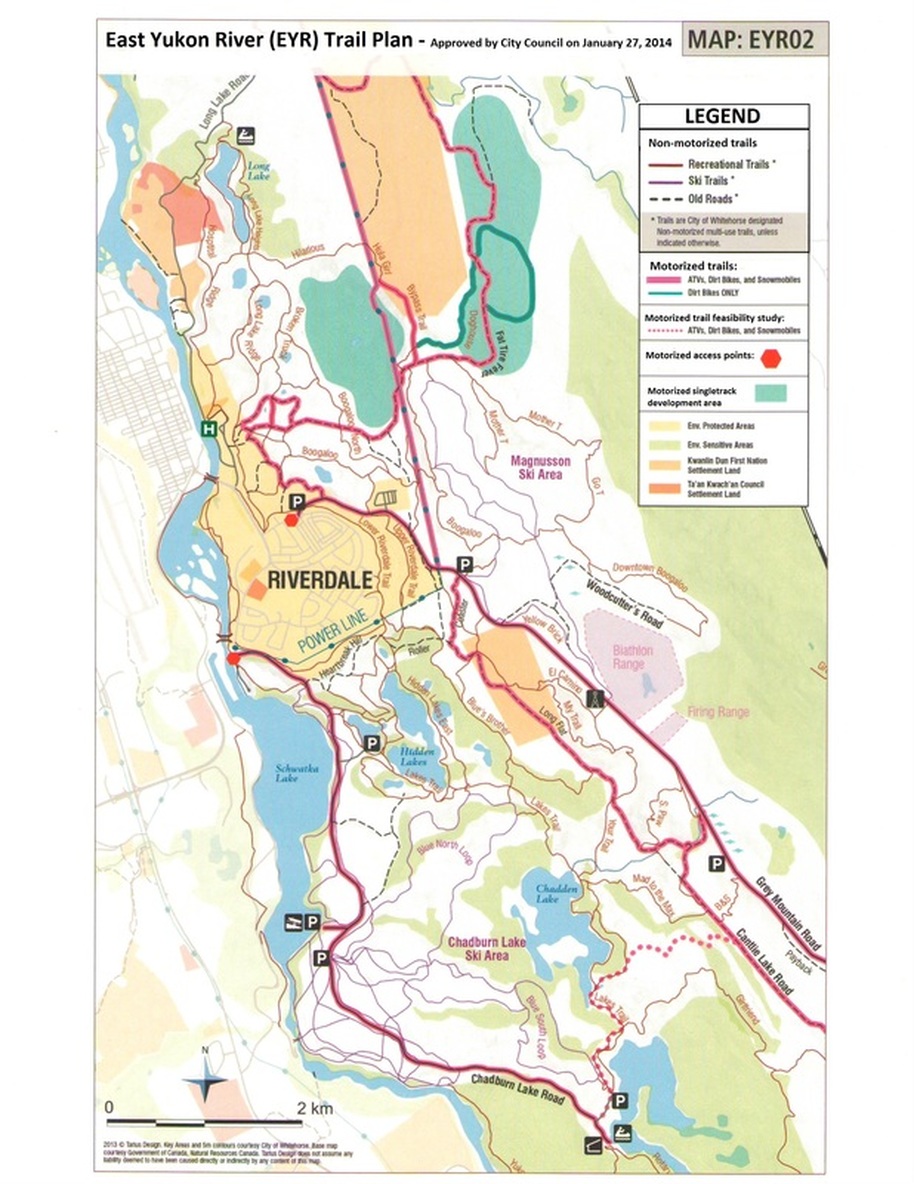
Trail designation for the Riverdale area, namely the East Yukon River (EYR) trail network, was finalized and approved by City Council on January 27, 2014. Click the icon below to view the approved EYR Trail Plan, to city limits.
| 140120_eyr_long_map.pdf | |
| File Size: | 2522 kb |
| File Type: | |
Operators of snowmobiles and ATVs are encouraged to keep their machines on the designated motorized trails shown on the above map. This will help to protect our environment.
The EYR trail designation had to be planned around the City’s Snowmobile and ATV Bylaws, which allow these off-road-vehicles (ORVs) to use City streets only to access designated motorized trails. ORVs are prohibited from downtown, Robert Campbell Bridge, Hospital Road, the portion of Lewes Boulevard between the bridge and Alsek, and the Millennium Trail. Snowmobiles are prohibited from sensitive areas, and ATVs (including motorbikes) must stay on designated motorized multi-use trails.
Non-motorized trails:
The final EYR map designates as non-motorized all trails in Riverdale, including Lower Powerline. The much debated Pee Wee Hill and Hidden Lakes areas will remain non-motorized, as they include extensive Environmentally Sensitive Areas. Those areas are prohibited to snowmobiles. A non-motorized Pee Wee Hill was also deemed safer for all users of this extremely popular area.
Motorized multi-use trails:
There are two routes for ORVs to exit Riverdale: Grey Mountain Road and Chadburn Lake Road.
An extensive network of motorized trails have been designated north and south of Riverdale, and these motorized trails can be reached by driving a short distance up Grey Mountain Road.
What needs improvement:
Active Trails Whitehorse Association (ATWA) was involved from the beginning of this process and participated in the 2012 EYR Task Force. It soon became clear to us that the composition of this task force overly represented pro-motorized interests in a ratio that did not reflect the actual residents' and trail users' ratio, and that some important guidelines from various city plans were ignored.
The outcome of the 2012 EYR task force was a December 2012 EYR map that was proposing a multitude of motorized trails, to which ATWA ,as well as many residents, strongly objected. City Council requested further consultation. A subsequent September 2013 EYR trail survey resulted in the majority of respondents opposing the December 2012 EYR proposal. (see below)
ATWA is grateful that City Council listened to the voice of residents, and requested from administration a more balanced plan. The modified November 2013 proposed plan was based on the September 2013 survey’s results, and was a major improvement over the previous proposal. We heard that the final map (shown above) was acceptable to most, but that the process had been too prolonged.
To spare city resources and unnecessary contention, ATWA would like to see future trail planning based more closely on the City’s guidelines for trail designation and environmental protection, as well as task force composition that better represents residents.
|
September 2013 EYR survey results:
|
| ||||||
|
Some quotes from the September 2013 survey results, based on this June 2013 proposed map:
|
| ||||||
“I have little confidence in sufficient bylaw resources being allocated to monitor proposed motorized use (it hasn’t happened to date) & the proposal as is stands will just encourage more use, leading to more off trail use resulting in further degradation. Let’s keep the wilderness in our wilderness city!! “ (Page 6)
“The area within the Hidden Lakes being studied for MMU (i.e. motorized use) is out of the question. The slopes of the hidden Lakes are delicate and easily eroded. Noisy vehicles should be prohibited here. The quiet peace that most of us seek in this area would be ruined.” (page 9)
“Without enforcement, allowing Motorized vehicles on some trails means that many ATV and dirt bike riders will likely use all trails. Also even the proposed MMU trails are very popular routes for residents walking dogs or cycling with small children, and there have been regular instances where careless riding and high speeds create dangerous or at the very least very stressful situations. My recommendation would be less MMUSs overall - and a plan and budget for the enforcement of the new designations.” (page 10)
“The plan needs a reasoned approach to “out and away” trails and this is not it yet.” (page 11)
“… I am concerned of the noise and pollution that comes from more use of motorized vehicles in places that my family and I go to find peace and wilderness.” (page 13)
“I have seen running trails with trees pushed down for ATV access. That running trail now sees ATV’s on a regular basis.” (page 18)
“For goodness sake the city needs to stop wasting money on committees and just use some common sense! Restricted access to Hidden Lakes, primarily by making the Peewee Hill trail and the Roller Coaster trail non-motorized, is only going to benefit the city.” (page 30)
_________________________________________________________________________________________________________
UPDATE - January 27, 2014 Council meeting: City Council adopted the East Yukon River (EYR) trail plan for the Riverdale area . To view map of approved motorized trails, click on the icon below:
UPDATE - January 27, 2014 Council meeting: City Council adopted the East Yukon River (EYR) trail plan for the Riverdale area . To view map of approved motorized trails, click on the icon below:
| eyr_trail_plan_-_jan27-2014.pdf | |
| File Size: | 3102 kb |
| File Type: | |
We urge residents with snowmobiles and ATVs to only operate their machines on the approved motorized trails shown in the above EYR map.
______________________________________________________________________________________________
______________________________________________________________________________________________
|
Riverdale Neighborhood Plan:
|
| ||||||
Excerpts from City plans below. The full documents are available on the City's website: www.whitehorse.ca
Excerpt from 2010 Riverdale Neighborhood Plan,
Section 1.5.3, Questionnaire outcome, (seventh paragraph, p.9):
“Motorized recreational vehicles (ATVs, snowmobiles) were identified as a major point of contention in the community. Many feel disturbed by motorized activity and identify it as a safety issue, particularly in regards to children. The consensus seems to be that laws regarding these vehicles are not being respected and must be more stringently enforced.”
“Furthermore, trails need to be strongly designated as motorized or non-motorized. Many also expressed concern regarding the erosion of trails, and general environmental damage caused by these vehicles.”
Excerpt from the City of Whitehorse 2010 Official Community Plan, (last three paragraphs, page 76):
18.5 Motorized recreation
“Many residents of Whitehorse enjoy motorized recreation, such as ATVs and snow machines. However, not all residents appreciate motorized vehicles on local walking and skiing trails. To avoid conflict between motorized and non-motorized trail users, the City Parks & Recreation Master Plan and Trail Plan recommend the idea of “out and away” trails. These trails would be designated for motorized use, allowing those residents routes to get away from the local green space and into the larger hinterland, where they will not be a nuisance to non-motorized users.”
18.5.1 “Where feasible, consideration shall be made to separate multi-use trails (which accommodate motorized and non-motorized recreation) from non-motorized trails. Future multi-use trail development shall avoid environmentally sensitive areas wherever possible.”
18.5.2 The trail Plan recommends the creation of a map of “out and away” trails for motorized recreation vehicle usage. This map shall be designed to strongly discourage the use of all terrain vehicles on non-motorized trails and in environmentally sensitive areas.”
Excerpts from 2007 Trail Plan
6.1 Priority Issues (second paragraph, p. 19)
Trails-specific
· Designate non-motorized trails near neighbourhoods
· Separate motorized and non-motorized uses, or coexist with respect
· Do not limit motorized use
· Need clearer trail hierarchy and linkages
· Trails are essential links between community facilities and points of interest
· Increasing level of conflict between trail users
· There are seasonal concerns with use, maintenance, etc
· Certain well-used trails should be designated as “core” trails
· Trails maintenance, safety are very important issues; more coordinated effort needed between jurisdictions, departments
· Recognize that resources for development, maintenance arelimited for what has proven to be a huge network of trails
Parks & Open Space
· Create designated greenbelts around existing neighbourhoods that are protected from development
· Increase protection of environmentally-sensitive areas
· Greenbelt protection and trails go hand-in-hand
· Fire protection and safe access/egress are increasing concerns
7.1 The Basic Links (first paragraph, p. 22)
Before getting down to the detail of individual trail designation, it is important to view the entire trail system conceptuallyas a series of nested connections.
First, there is a need to connect people to places within their neighbourhoods …
Second, there is a need to connect neighbourhoods to each other and to facilities which serve more than one neighbourhood, such as schools. …
Third, there is a need to interconnect the various City parts as a whole. … by making such alternatives easy and time effective, further encourages healthy lifestyles.
Fourth, again on the City-wide level, there is a need to encircle all of the neighbourhoods and destinations with a loop trail. This outer ring trail allows motorized connections between neighbourhoods and applicable destinations at a distance far enough away from neighbourhoods to lessen the chances of user conflict. It also allows the more adventurous non-motorized users a more extensive perimeter loop trail, taking them far from their own neighbourhoods.
Lastly, there is a need for escape routes, trails which allow residents to leave the limits of the City entirely. These are the “getting the heck out of Dodge” trails which facilitate escape from urban form and connect the City to a broader network of trails and destinations beyond its boundaries. It is particularly important that motorized users have appropriate urban/rural interface routes which allow them the opportunity to recreate at distance from built-up areas.
“8.2 Designations for Multiple Use Trails” (third paragraph, page 25)
“Neighbourhood Trails - majority of trails within a designated distance from established or new neighbourhoods; maximum 500 m distance dictated by geography, trail conditions – trails one might use on an evening ½ hour dog walk.”
“City Trails (Non-motorized) - major trails of City-wide importance, key inter-neighbourhood connectors or urban / rural interface trails (trails that lead beyond City limits).”
“City Trails (Motorized) – major trails of City-wide importance, key inter-neighbourhood connectors or urban/rural interface trails (trails that lead beyond the City limits); these trails are specifically designed and designated to allow motorized traffic.”
“Hinterland trails – trails beyond the designated distance from neighborhoods, usually non-motorized but may accommodate minor motorized use.”
“Trails to be Abandoned – trails and trail sections to be decommissioned & reclaimed or rerouted for safety, habitat protection or other reasons.”
Excerpt from Minutes of January 23, 2012, Council Chambers
“Administration confirmed that currently there are no out and away trails for the Riverdale area. The intent would be to strike a community task force to establish out and away trails both north and south.”
Source (page 12): http://199.192.184.59/Home/ShowDocument?id=1822
| 0_excerpts_from_ocp__riverdale__trail_plan_full_quotes.pdf | |
| File Size: | 464 kb |
| File Type: | |


